Trail Walking La Ferté-Vidame - [Itinéraire] La chapelle de Réveillon - Photo

[Itinéraire] La chapelle de Réveillon

 ODDAD78
ODDAD78

User

© OpenStreetMap contributors
Length
Length
11.5 km
Max alt
Max alt
269 m
Uphill gradient
Uphill gradient
94 m
Km-Effort
Km-Effort  
12.8 km
Min alt
Min alt
230 m
Downhill gradient
Downhill gradient
94 m
Boucle
Boucle
Yes
Creation date :
2023-08-26 07:58:19.207
Updated on :
2023-08-26 08:03:21.778

(0 Reviews)

Walking
Walking
2h53
Difficulty : Difficult

Scan this QR Code to open this trail in the SityTrail application

FREE GPS app for hiking

Logo SityTrail SityTrail

IGN / Geographical institutes

Download SityTrail from the App Store Download SityTrail from Google Play

Logo SityTrail SityTrail World

The world is yours!

Download SityTrail from the App Store Download SityTrail from Google Play Download SityTrail on Huawei AppGallery

About

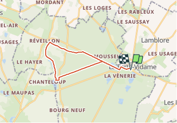
Trail Walking of 11.5 km to be discovered at Centre-Loire Valley, Eure-et-Loir, La Ferté-Vidame. This trail is proposed by ODDAD78.

Description

Départ : La Ferté-Vidame Arrivée : La Ferté-Vidame Balisage : PR
Communes : 1. La Ferté-Vidame
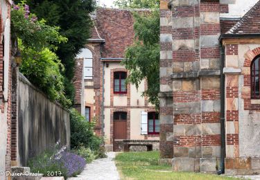
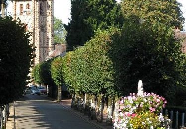
1. A La Ferté-Vidame, depuis la grille d'entrée du parc du château (Office de tourisme), suivre la rue du Temple, passer devant l'église St-Nicolas (plaques explicatives). Continuer rue du Général- Leclerc. Traverser la D4 pour s'engager entre les alignements de tilleuls à droite du bassin. Dépasser le rond Victoire et arriver au rond de Montpensier par la contre-allée longeant la route.
2. Dos au village et au château, prendre à gauche la large allée empierrée de Montpensier (allées privées, passage autorisée). Au rond de Blagny, continuer tout droit et atteindre la D317.1.
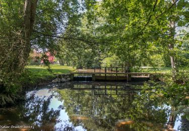
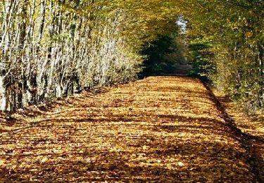
3. Suivre la route à gauche sur environ 150 m. Prendre le chemin à droite qui descend jusqu’à la digue de l’étang Neuf.
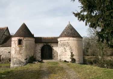
4. Tourner dans le chemin à droite qui, après avoir longé l’étang de Buternay, atteint la D 317.2 près de la chapelle de Réveillon (ruisseau de Buternay et chapelle de Réveillon à 50 m à gauche, plaques explicatives).
5. Après avoir coupé la D 317.2, prendre en face le chemin herbeux qui conduit au Haut-Coudray. A la dernière maison, prendre à droite le chemin bordé d’arbres qui remonte vers les bois. Traverser la D 117.1 et continuer en face. Le chemin s’incurve vers la gauche, coupe la ligne de la Chapelle- Fortin et atteint la D24 un peu au dessus du rond Saint-Simon.
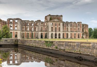
6. Suivre la route à droite (belle perspective sur les ruines du château de La Ferté-Vidame). Retrouver le Rond Montpensier.
Pour le retour au bourg, suivre le bord des bassins de l'autre côyé de la route puis, à partir de la rue du Général Leclerc, retrouver l'itinéraire de l'aller (ne pas manquer d'aller visiter le parc, le sentier des insectes, les ruines du château).
(Pas à pas : Rando-Perche)

Elevation profile

Positioning

Country:
France
Region :
Centre-Loire Valley
Department/Province :
Eure-et-Loir
Municipality :
La Ferté-Vidame
Location:
Unknown
Start:(UTM)
345234 ; 5386284 (31U) N.

Trails nearby

Trail Walking La Ferté-Vidame - La Ferté-Vidame - Longny-au-Perche (Longny-les-Villages) 23 km - Photo
Walking

Walking

Very difficult
La Ferté-Vidame, Centre-Loire Valley, Eure-et-Loir, France
23 km | 25 km-effort
5h 35min
No
Trail Walking La Ferté-Vidame - Traversées Percheronnes La-Ferté-Vidame - Tourouvre Etape 4 du TCP 28,7 Km - Photo
Walking

Walking

Medium
La Ferté-Vidame, Centre-Loire Valley, Eure-et-Loir, France
29 km | 33 km-effort
7h 9min
No
Trail Walking La Ferté-Vidame - La Ferté-Vidame - Moutiers-au-Perche (TCP) 28 km - Photo
Walking

Walking

Easy
La Ferté-Vidame, Centre-Loire Valley, Eure-et-Loir, France
28 km | 32 km-effort
7h 1min
No
Trail Walking La Ferté-Vidame - La Ferté-Vidame - Saint-Maurice-lès-Charencey 15 km - Photo
Walking

Walking

Easy
(1)
La Ferté-Vidame, Centre-Loire Valley, Eure-et-Loir, France
15.3 km | 16.9 km-effort
3h 34min
No
Trail Walking La Ferté-Vidame - La Ferté Vidame 6 - Photo
Walking
togolo28

Walking

Easy
(1)
La Ferté-Vidame, Centre-Loire Valley, Eure-et-Loir, France
8.2 km | 9.1 km-effort
1h 58min
Yes
Trail Walking La Ferté-Vidame - La Ferté-Vidame - Senonches 17 km - Photo
Walking

Walking

Easy
La Ferté-Vidame, Centre-Loire Valley, Eure-et-Loir, France
16.7 km | 18.5 km-effort
4h 36min
No
Trail Mountain bike La Ferté-Vidame - Autour de la forêt (Etape 1) -  La Ferté-Vidame - Photo
Mountain bike
tracegps

Mountain bike

Medium
(1)
La Ferté-Vidame, Centre-Loire Valley, Eure-et-Loir, France
19.5 km | 22 km-effort
2h 0min
No
Trail Walking La Ferté-Vidame - Autour de la forêt (Etape 1) -  La Ferté-Vidame - Photo
Walking
tracegps

Walking

Difficult
La Ferté-Vidame, Centre-Loire Valley, Eure-et-Loir, France
19.5 km | 22 km-effort
5h 19min
No
Trail Cycle La Ferté-Vidame - La Chapelle de Réveillon - La Ferté Vidame - Photo
Cycle
tracegps

Cycle

Easy
La Ferté-Vidame, Centre-Loire Valley, Eure-et-Loir, France
16.7 km | 18.5 km-effort
2h 0min
Yes


Close
My subscriptions